Walking the Line
The last leg of my summer tour with five different Extension partners found me at the New Hampshire state office of the Natural Resources Conservation Service (NRCS). I helped Jeremy Lougee, Easement Specialist at NRCS, with easement monitoring baseline reports.
I had already learned about how easements work from my time spent with the Southeast Land Trust of New Hampshire. To refresh, an easement is a legal contract between a property owner and an organization (in this case, the NRCS) that restricts development on a piece of land. In this way, the land is conserved and natural resources are protected. Thanks to the Farm Bill, renewed this year, the NRCS is in a position to help landowners restore and preserve wetlands on their properties.
Once a property has an easement, the NRCS begins restoration and monitoring. Usually within one year of establishing the easement, Jeremy visits the property to walk the boundary, make note of identifying and unusual features, and assess the overall condition of the property. This information is then compiled into a detailed baseline report and is filed for use as a reference in future monitoring trips.
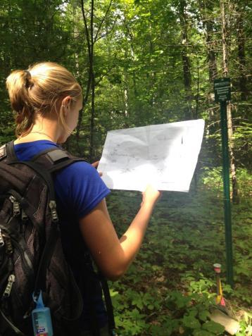
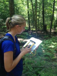
After a brief orientation about this process on my first day, Jeremy and I headed out into the field armed with a survey of the property and a Trimble unit. Using the survey, and guided by the GPS in the Trimble, we found each boundary markers that the surveyors had set (not the easiest thing to do—markers are often in tricky, hard to get to spots!) and photographed the point. We also made note of the types of wetlands and forests that were in the area, as well as if there were any invasive plants. Any features, such as ponds, streams, fields, or rock ledges, were also photographed and observed. We also looked for encroachment onto the easement from neighbors.
All of this information is included in a baseline monitoring form. When another monitoring trip is taken, these forms and pictures are referenced so the original condition of the property can be maintained. Baseline reports will be used for decades to come by the NRCS.
During my two weeks at the NRCS, Jeremy and I were able to complete seven baseline reports, two of which I did completely on my own! The properties, located all around Rockingham County, varied in size from about 40 acres to over 130 acres. Surprisingly, size has little to do with how quickly one can complete a monitoring trip; the smallest parcel took three-quarters of a day to complete, while I was able to complete two relatively large properties in the same amount of time.
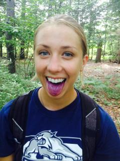
I was also able to see a lot of different and unique types of wetlands. On one property, we saw an Atlantic white cedar swamp. Atlantic white cedars are very uncommon in this area, but this swamp is being managed to favor the cedars. We visited a black gum swamp, also relatively uncommon. While the trees were amazing, my favorite part of that swamp had to be the incredible wild blueberries. I ate so many as we were walking, my tongue turned purple!
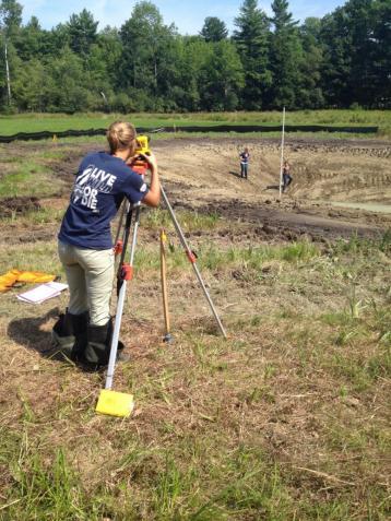
On my final day of monitoring, Jeremy took me to a restoration site on one of their properties. The easement team is constructing a pond and planting natural shrubs to help restore New England cottontail rabbit habitat. It was so interesting to see the plans that I may one day be designing put into action, and I also learned to take depth measurements using a transit.
I learned so much from my time doing baseline reports. My tree identification became even stronger, and I learned how to identify past land use practices based on the current condition of a forest or wetland. I also became proficient in many functions on ArcMap and am now skilled in interpreting land surveys.
Maybe most useful of all, I gained a much better sense of direction! As someone who can get lost in a cardboard box, I was nervous about going into the field armed only with a GPS unit that loses signal from time to time. From walking through dense shrub layers as well as open forest, my internal compass has really stepped up its game.
The two weeks I spent at the NRCS flew by! I had so much fun traveling to all of the different properties with Jeremy. I can’t think of a better way to wrap up my internship!
My experiences this summer have really opened my eyes to the intricacies and breadth that stewardship and conservation covers. As a future environmental engineer, working in the natural resources world this summer has given me a new and fresh perspective on different aspects of working for and in the environment, something that I can incorporate both into my classes and future career.
I would like to thank UNH Extension and all the partners I worked with for the incredible opportunities I have been given this summer. I had a blast and am looking forward to all that the Network (now Nature Groupie) will be able to accomplish in the future.